
In Jewish Sites
The minhag of the area
In the cycle of Daf HaYomi, maseches Bava Basra has been recently started in the learning schedule. The first mishnah concerns itself with two people who are joint owners of an area which they wish to divide between them by means of erecting a fence.
Buildings, walls and many remains that are found in hundreds of excavated archaeological sites around Eretz Yisrael can be associated with various eras in history, from the times of the Tanach up until the nineteenth century CE.
In general, it is possible to categorise the building by its style. There are certain styles of building that were used in the Canaanite era, at the time of the conquest of the Land by Yehoshua – such as are found in Tel Be’er Sheva or in Rosh Zayit. Whoever visits historic sites in the country that date back to Roman times, can recognise a particular style of architecture which is common to any area that found itself under Roman conquest during that period of time.
The era of the Chashmona’im also has its own particular style of building which distinguishes it from the styles used before and after. The Arabs too, who ruled over Eretz Yisrael for hundreds of years in later times, had their own distinct style of architecture.
The various styles differ in the way in which they used the stone, the sizes they preferred, the methods they used to join them together in a structure between the stones, between tiers and between walls.
It is particularly interesting to examine the structures left behind by the Crusaders in Eretz Yisrael. The Crusaders did not import their own stone for building purposes; they dismantled already-existing structures standing in the area, and took the stones to build their own new structures. This often causes confusion for archaeologists, who find Crusader-age buildings constructed from stone hewn in a much earlier era, even stones dating back to Herodean times, or even further back to the times of the Chashmona’im.
Therefore, one can find, for instance, at the Crusader fortress today known as ‘Kochav haYarden’, stone that was removed from the doorframes of an ancient beis knesses. The rest of the building is similarly constructed from stone taken from earlier periods, even back to the times of Bayis Sheni.
In this series of articles we will examine areas containing findings from various different eras.
Different customs – different eras.
Chapter One – Crusader Fortresses
In this first chapter, we will deal with three separate Crusader fortresses, which were constructed in Eretz Yisrael during the period of the Crusader Kingdom in Eretz Yisrael. During this period, around fifty different fortresses were built in Eretz Yisrael and surrounding regions.

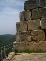
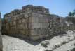
The Crusader fortress at Kochav haYarden
Near the town of Beit She’an, on the eastern side of the settlement of Ramat Yisasschar, perched on a high cliff is the most striking of the Crusader fortresses in the Holy Land.
The Crusader fortress of Kochav haYarden was built approximately in the year 4904 (1140CE) and was first intended as a protected farming settlement. However, the family who owned it was unsuccessful in maintaining it, and were forced to sell the fortress after not too many years had passed. In the year 4928 (1168CE), it was sold to the order of Knights of Hospitalery a Christian order. After some five years of work at the site, by hundreds of labourers, the fortress was transformed into a valuable asset.
As is known, the Crusaders built many striking fortresses all over the country, including the ones at Ein Chemed, Migdal Efek and others; however, the fortress at Kochav haYarden is certainly the most striking and most perfectly designed of them all. Another advantage of this fortress is its location; at a height of 312 metres above sea level, on the highest cliff in the region, it boasts stunning views of the surrounding area, and as such, it was given its name in French ‘Bellevue’, meaning ‘beautiful view’. The fortress was also named ‘Coquette’, which means ‘charming’ in French.
From this vantage point, one can discern the ruins of the town of Kochva from the times of Bayis Sheni. The town was dismantled, and its stones were used to build the Crusader fortress. When archaeological excavations were undertaken here, nine stones from the ancient beis knesses in the town of Kochva were discovered.
On one of those stones, a picture of a menorah was found, with seven stems and four lines of writing in aramaic (out of five, the last of which had been erased over time), which read; “[in memory of such-and-such a person] who provided this lintel out of his good heart and from his own possessions – amen amen selah”.
The structure of the fortress attests to meticulous planning. It is located on a high plateau, and its exterior walls are surrounded by a deep ditch which prevented chariots from approaching to besiege the fortress. Within the exterior walls was another surrounding wall, to provide an extra layer of protection in the event that the exterior walls were breached. These surrounding walls are three metres thick, extremely strong and constructed from basalt rock.
The exterior wall of the fortress itself has four giant towers in it that were used for observation purposes, one at each corner of the building. On the outermost wall, there are eight identical towers, one on each corner and another one at the centre of each side. Each tower had openings sealed with iron-plated doors.
All these reinforcements were to protect the fortress from aspiring conquerors, which was a realistic fear at the time. Between the years 4940 and 4944 (1180 – 1184CE) there was fierce fighting in the region of the fortress, between the Crusaders and the Moslems. However, the fortress itself did not fall. Even when the soldiers of Salah-a-Din arrived three years later, they also did not manage to penetrate the fortress – only after a siege lasting a year and a half, when most of the Crusader Kingdom had already been vanquished, did the soldiers of Salah-a-Din manage to conquer the exterior tower of the fortress, and then the knights there were forced to surrender and sign an agreement allowing them to leave in peace with their belongings and go to the town of Tzur (Tyre), which was still held by the Crusaders at that time. This privilege was granted them because Salah-a-Din admired their courage and determination in persevering for so long against their besiegers.
Immediately after the expulsion of the Crusaders, Moslem peasants settled the area, and in the year 4988 (1228CE) the Sultan of Damascus of the time, Mellich al-Muezem, ordered the destruction of the fortress down to its foundations, to ensure that the Crusaders would not be able to return and reoccupy it.
At the beginning of the eighteenth century CE Bedouins settled the site and established a village there, which they called Kauchav-al-Heva, which translates from the Arabic as ‘Star of the Winds’. This village became known in later times for its hostility to British rule during the Mandate period, and also for its enmity to the Jews of the region.
In the year 5708, during the War of Independence, the village was deserted, abandoned by its inhabitants. Twenty years later renovations were undertaken in the area by the National Parks Authority, and then the region was opened to the public.
 |
| Crusader fortress י[צלם] |
 |
|
| The Crusader fortress at Ein Chemed |
צלם |
On the main highway heading north from Yerushalayim, in the area of Pinat Chemed, Morika and Shuafat, is the Crusader fortress of ‘Aqua Bella’.
Just ten minutes from western Yerushalayim, on the Kislon river, is another Crusader fortress, one of the many that they built in Eretz Yisrael. The area is known by its French name ‘Aqua Bella’ which was given to it by knights of the Hospitalery order – the name translates as ‘Beautiful Waters’, after the spring which is found in the surrounding area. The area is also known as ‘Dir al-Banat’, the Arabic term for a convent, even though most historians believe that there was never a convent in that area – it was always a farming region.
The fortress here was built between the years 4900 and 4920 (1140-1160CE) during the time of the Crusader King Follak Manjo. During this period, additional Crusader fortresses were also constructed, including the ‘Belmont’ fortress in Tzova and the ‘Emmaeus’ fortress in Latrun. However, the fortress in Ein Chemed differs from other Crusader fortresses in that most of the remnants from it are from the times of the Crusades and not from previous eras, and therefore, it is not built on higher ground as are other fortresses, but on relatively low-lying ground, and it is only the abundance of springs around the fortress that provide a reason for its construction in such a location.
The fortress at Ein Chemed measures thirty by forty metres, and the walls are two metres thick. It has two floors. The fortress faces south and this wall rises to a height of twelve metres. There are several gates and two large halls inside with vaulted ceilings, and also a courtyard in which are the steps that lead to the second floor. The southern part of the fortress borders on an ancient Moslem cemetery.
In the year 5744 (1984CE), the British archaeologist Dennis Pringle arrived in Eretz Yisrael, wishing to investigate the Crusader period. He visited the Ein Chemed site ‘Aqua Bella’ and established that the site had been used as an agricultural settlement, secured by the fortress whose protection was sought owing to the water sources in the region. He found confirmation for his contention when a warehouse of sorts was uncovered in the courtyard of the structure. The fact that the location was on the main highway leading up to Yerushalayim strengthened the investigator’s belief that the fortress was used as a way-station for pilgrims on their way to the ‘holy sites’ of Yerushalayim, and was also a convalescent home for sick knights or injured people.
It appears that this was not a particularly important site for the Crusaders, since no mention of it has been discovered save for a document describing the sale of the fortress in the year 4928 (1168CE) to a Hungarian duke, the proceeds being needed to provide for the costs incurred by the pilgrims – but in the end, the duke did not arrive in Eretz Yisrael to take residence there.

Today, the fortress stands on the National Park grounds of Ein Chemed and comes under the auspices of the National Parks Authority which itself conducts archaeological investigations. The area has excellent views of the surrounding region and attracts many tourists.
The Monopor fortress

On the southern bank of the Caziv river, on a narrow and winding tributary, stands the Monopor fortress, whose name translates into Hebrew as ‘the strong mountain’. The fortress is also known as ‘Kilet Kora’in’ in Arabic, or ‘the small foundation fortress’ owing to its location at the mouth of the tributary of the river.
This is a typical Crusader fortress in its style of architecture; however, it differs from other fortresses in Eretz Yisrael in that it is one of the two in the Holy Land established by a smaller order of knights, the Tabtony order associated with German knights. In addition, the Monopor fortress was initially established as a guarded farming community, not for military purposes.
In the course of archaeological excavations conducted at the site, in which coins, pottery and other items were unearthed, it emerged that the fortress had first been erected at the beginning of the period of the Roman Empire’s rule in the area, although the fortress only gained prominence in the Crusader era when German knights re-established it in the year 4986 (1226CE). These knights built the fortress on the remains of the agricultural settlement that had previously existed there many years previously – the wealthy French aristocratic family ‘de Maily’ supplied the means to do so.
During the 1180s, the Arab conquest of the Holy Land commenced under the leadership of the Moslem Salah-a-Din who brought huge armies with him. As is known, the Arab forces succeeded in driving most of the Crusaders from Eretz Yisrael, and after the Moslem conquest of Yerushalayim, the Crusaders suffered almost total defeat. Later, Nachalat Me’ila and the Monopor fortress also fell to the Arab conquerors, but the Arabs assigned little importance to the Monopor fortress, and did nothing to restore it from its ruins after the battles that took place there.
In the year 4952 (1192CE), after the Crusaders had captured a substantial portion of Eretz Yisrael under the leadership of Richard the Lion Heart of England, an agreement known as the ‘Ramle Agreement’ was signed . This agreement allowed the Crusaders to establish a second Kingdom in the Holy Land, and to return to the Monopor fortress.
In the year 4989 (1229CE) the Monopor fortress was sold to the knights of the Taventy order, and they began to renovate it with the assistance of large donations from visiting pilgrims and from European Christians. After the renovation work was completed, an order of knights was stationed there, and many treasures were also stored there. This location now began to serve as a farming community and the fortress was used for many other purposes too. In order to better secure the region, the fortifications were reinforced and an additional tower was erected in the centre of the fortress, which is known as ‘Migdal Oz’.
In the year 5026 (1266CE) the great Mongol warrior Beibars arrived in the area, and he proceeded to besiege the Monopor fortress. However, he did not manage to defeat the knights guarding it, and it was only after five years, in the year 5031 (1271CE), when most of the Crusader strongholds in the Galil had been defeated, that Beibars returned to Monopor and managed to overthrow it. He allowed the knights of the order there to leave in peace with their possessions, weapons and archives. After the Crusaders had left, Beibars ordered that the fortress be demolished to make it impossible for the Crusaders to return and reoccupy it. The fortress was then destroyed almost entirely, except for ‘Migdal Oz’ which remained almost intact.
The remains of the fortress which can be visited today were once surrounded by a stone wall, which served as a first line of defence against attackers. At the entrance to the fortress there was a great hall, which appears to have once served as a meeting place for the knights of the order. At the centre of the hall there was a octagonal pillar, from which issued wide arches which supported the ceiling.
As was already mentioned above, at the centre of the fortress was ‘Migdal Oz’, which was built of large impressive stones with intricate carvings. The tower had its own water well, which was destroyed. To the north of the tower there were armoury workshops, a kitchen, a large mess hall, a wine press and another smaller hall. Nearby was the entranceway, of which only a small part has been preserved to the present day.
Within the grounds surrounded by the fortress was a special dam to divert the waters of the Caziv River, which were then used to water the crops of the agricultural settlement that was established there from the first days of the fortress, and which also powered a flour mill.
Today, the site is a National Park, under the auspices of the Nachal Caziv Nature Reserve.

Eliyahu’s Cave On the slope of the Mt. Carmel in Haifa is found Eliyahu's Cave from where Eliyahu called out, "Until when will you waver on both sides...".
Haifa – Nesher Park This location was already specified during the Mandate Period to be preserved as a Nature Reserve, and in the 50's was the site of planting of pine trees every Tu b’Shevat. The area was later neglected, and became nothing more than a dumpsite – and when the site was in danger of being entirely ruined, a rehabilitation project of Keren Kayemet l’Yisrael began, and took the area under its wing. The transformation was stunning and the attractions beckon. There is also a cable car running on steel cables which is also suitable for children.
‘The Custom of the Place’ Chapter 2: Buildings from a Bygone Era In this chapter we will deal with Beit Shearim - a town from the period of the Mishna, and take a look at the ruins of the ancient settlement ‘Megido’